![]()
|
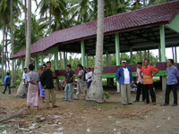
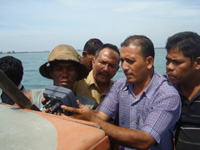
Tuesday, 16-10-2007 Meetings with Panglima Laot Lhok One of the first steps was to meet with Panglima Laot up and down the east and west coast of Aceh. These meetings facilitated by Panglima Laot Krueng... |

|
|
|
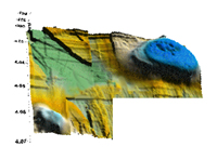
Thursday, 05-07-2007 Melati has a little sister Recent surveys of the area have identified another previously unmapped seamount. Discovered approximately 6 km northwest of Melati, part of the same ... |
|
|
|
|
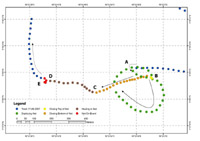
Tuesday, 12-06-2007 Identifying fishing grounds and Mapping ocean currents The image is of a typical purse seine signature, this is also how we can tell where the fishermen are dropping their nets. The boat goes very quickly... |
|
|
|
|
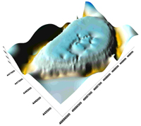
Saturday, 05-05-2007 First look at Melati This is a first look at a sea mount that the fishermen have identified that is not on any of the maps. Rises from a depth of over 1800 meters to with... |
|
|
|

|
Friday, 16-02-2007 Concept development Initially, there was a lot of questions as to whether the fishermen would allow themselves to be tracked. That they wished to keep fishing grounds se... |
|
|
|
|
Tuesday, 00-00-0000 GPS & navigation training for fishermen, Department of Fisheries staff, Navy As of April 31st, 2009 we have trained over 485 in GPS and traditional navigation. The praticipants were primarily Acehnese captains, but also includ... |
|
|
|